Why so secret? The Ajanta Experience

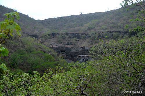
The first thing that strikes one is how thoroughly concealed these caves are. You can only see it once you are in the complex. No one, even a kilometre away, would have a clue that something like this exists. On three sides, it is hemmed in by hills. And from the north side, you only see the back of the hill. One can’t even see it from the MTDC facilities at the entrance. You climb up the stairs, turn round the curve of the hill and there in front of you, they stare back at you. It is not difficult to reach. But you will never know where is it.

Ajanta Caves, July 2014The first sighting of the caves, if you follow the present day access road


Every one knows the terrain and the shape and the contours and other topographic details of the caves.As the Waghor river snakes through the hills making one hairpin bend after another (or horseshoe bend), you have pairs of basalt hills side by side separated by the river. On one particular bend, the caves are cut on the southern face of a hill on the north bank. If you come from the north, you can’t see it. The hill on the south bank completely hides it from view if you are on the highway in the south. There are no access points from east or west as you have hills interlocking and creating a natural curtain of sorts.

Waghora River, Ajanta, July 2014
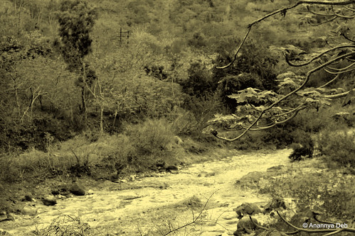
Following the Waghor river from the north east side towards the caves


My immediate thought was that these caves were designed for absolute seclusion. Almost all the other cave monasteries that I have been to can be seen from the plains below. Travelers on the road below can sight them easily and work their way towards them for shelter and or enlightenment. Not so for Ajanta.

A similar concept can be seen in forts where the gates are hidden from view. But the difference is that the fort builders have to design and build their fort walls in a way such that the gates are hidden. In the case of the caves of Ajanta, the effect of concealment is a natural feature.

After pondering all this, my next thought was why and how did the first batch of monks choose this location. Were they being persecuted and needed to hide? Were they working on something that was very sensitive and needed to be done in a place where there was no prying eyes. Kanheri and similar caves provided seclusion but they were very much open to public view. Who selected this location? Did that person have a similar accidental discovery as the Englishman who found it in the early part of the 19th century? There must have been something in the Buddhist pioneer’s mind which led him to pick this very specific horseshoe bend of the river. One will never know and therefore one can only imagine many possible scenarios, one as crazy and wild as the other.

Cave 9, Ajanta Caves, July 2014
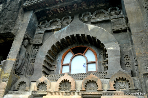
Cave 9, a chaitya hall excavated circa 1st century BCE, part of the initial set of caves


Once one cave was excavated, circa 2nd century BCE, and populated by a few monks, the other caves started coming up. This went on for hundreds of years till about the 1st century CE. Walter Spink, one of the leading researchers on Ajanta, is of the view that the caves were abandoned from the 2ndt century CE till the 5th century CE. After that, for about a hundred odd years, kings, noblemen and commoners donated to the excavation and artistic development of the site which was now inhabited by a new generation of monks. Which means that the place was well known in most parts of the country in those times and Buddhist monks consciously chose that secluded spot for their monastery. Here again there are some thoughts that get triggered as you see each cave.

Monks would most probably be drawn to this complex because the incumbent people must have been some kind of masters and leaders in their field of thought. Almost every cave which served as a dormitory had at least three discussion spaces – a large pillared hall inside, a verandah and an open courtyard by the river. Spending time with these monks must have been extremely fruitful for students of Buddhism – both young initiates into the monastic order and visitors who cut across royalty and commoner. This is validated with the inscriptions found everywhere. It is also validated by various travelogues of those times including Huein Tsang.

The level of artistic brilliance on display is at a level far superior to what we see today. Let’s assume that craftsmen of those times produced extraordinary work for even the most mundane commissions. But this is not a mundane commission. This is an ultra secluded Buddhist sanctuary, one of thousands in the country, virtually invisible even to villagers in nearby areas and the craftsmen produce work which is, as per all the such caves which have been studied, one of the best there is. Surely they were briefed that these caves were special. So what was so special that was happening in this cave, first between the 2nd century BCE to 1st century CE and then again in the 5th century CE?

Cave 29, Ajanta Caves, July 2014
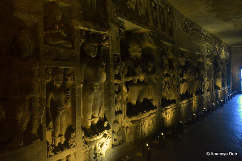
Cave 29, one of the last caves to be done, outdoes all the others in terms of the sculptures


And why did it disappear from all consciousness? Coming back to Kanheri, there are inscriptions of 11th century CE of Parsees visiting the caves and meeting the Buddhist inmates there. Which means for at least 600 years after the last known inscription in Ajanta, Kanheri continued to function. But Ajanta seemed to have gone into a decline earlier than the others.

Walter Spink puts it to the decline of Buddhism and the rise of Hinduism as the state religion of most monarchs in the Deccan Peninsula. This loss of royal patronage could be one of the reasons. Possibly, the secret location turned out to its own nemesis as the monasteries remained out of sight and out of mind for most people, especially the various new empires, like the Rashtrakuta (which sponsored the Ellora Caves and some of the Elephanta cave temples), Chalukyas, etc. many of whom might still have supported them as they were known to be secular.

So who were these Buddhist masters who needed such an extreme level of seclusion? Did they achieve their goals which they had set for themselves? And who were the craftsmen who created all these works which would lie hidden in the jungles for over 1400 years?

More photographs of my Ajanta trip can be found here.

Discovering the Big History in Small Towns

In the last 10 years I have had the opportunity to visit a number of small towns (population less than 1 million) both on holiday and on work. And uncovering the often forgotten history in these small towns is a very interesting exercise. Here, listed in alphabetical order, are 8 small towns  that I recommend for those who have this bent of mind. Specifically, I have taken those places which have a relatively low profile in most travel guides. Hence no Rajasthan, no Goa, no Kerala.

1. Badami, Karnataka (Pop: 26,000)

Badami, February 2010

Known as Vatapi in ancient times and in most of the scriptures, Badami came into prominence in the 6th century CE when Pulakesin I made this the capital of the Chalukyan Empire. Over the years, Badami has seen many other regimes including Islamic rule to create a culturally mixed town. It’s economy is largely agrarian and the few hotels which are there just about manage to survive on the meagre tourist trade. Pattadakal, a UNESCO World Heritage Site, is a place worth visiting as it is the earliest extant site of high quality structural temple architecture. And Aihole, a former trading town, is the source of South Indian temple architecture. (My earlier posts on Badami and the Chalukyas.)

2. Bijapur, Karnataka (Pop: 326,000)

Bijapur, March 2013

The name of the city means “City of Victory”. Its glory days came under the reign of the Adilshahi dynasty, from the end of the 15th till late 17th century when it was finally taken over by Aurangzeb. Bijapur represents the quintessential Indian small town with a rich history. There are three different layers (a) the monuments of the past which are numerous and will take you a day and a half to cover the entire lot, (b) the cultural practices that remain as a legacy of the past – the tonga rides, the biriyani shops, the large, juicy Mediterranean and Central Asian origin fruits in the markets (c) and finally the modern town itself, a semi-industrial semi-trading zone with its share of rich landlords and poor labourers, a social and economic divide that cuts across the country.

A number of people, after looking at some my photos and blog posts on Bijapur have written to me that these reminded them of their college days when they used to roam around here. Well, that is a compliment and if my posts trigger such happy moments, well, I would consider it a job well done by me.

3. Machhilipatnam, Andhra Pradesh (Pop:183,000)

Machilipatnam Beach, October 2009

A 90 minute bus ride from Vijayawada, I spent a day here, taking my Sunday off while on a field trip. The town, a port known as Masalia to ancient Romans and possibly a source of a fabric that was named muslin because it was shipped from here (there is an equally strong claim made by Mosul in Mesopotamia / Iraq). Being a trading centre has its advantages – people get exposed to different cultures. The French and Dutch traded here as did the British. Machilipatnam was the source and destination of trade from the princely state of Hyderabad.

The beach at Machilipatnam, just south of the town centre, was damaged during the 2004 Tsunami. In case you still had any doubts about the name of the town, the elaborate figures in the entrance gate of the beach should put those doubts at rest. On a Sunday afternoon, most of the shops were closed, possibly for weekend siesta. This prevented me from exploring the kalamkari work that also originates from here.

4. Ratnagiri, Maharashtra (Pop: 70,000)

Thebaw House, Ratnagiri, August 2008

Ratnagiri, though a small place, has some very interesting history. As a sea port, it was right in the middle of the Indian Ocean trade activities, harbour for both kosher merchant ships and pirate ones. It is the birthplace of Tilak. It is also the nearest urban market to buy Alphonso mangoes. You can of course venture out into the mango farms along the Konkan but if you don’t feel like doing all the work, then pick it up from the local markets.

Thebaw House, where the last king of Burma was exiled and died, is now a museum. Walking and exploring this colonial bungalow is quite an experience. From the balcony, one can’t see the harbour anymore (there’s too much of construction in the foreground).

5. Salem, Tamil Nadu (Pop: 830,000)

Salem Bus Stand, September 2010

Salem steel was a household name but I had no idea there was a town called Salem. Actually, I did not explore this town very extensively. I was on work here and was confined mostly to the hotel and the conference rooms. When I did have a day off, I went off on day trips to Hogennakal and Yercaud.

I do remember the Salem bus stand from where I got buses to the two places. One of my observations about bus travel (using state transport) has been that South India and Maharashtra have the most efficient and reliable services. And at Salem bus stand, I experienced TN buses. In spite of the language barrier, I could still get to my destinations error-free.

Not surprisingly, a lot of my free-wheeling travel have been in these states of the peninsula / Deccan.

6. Shillong, Meghalaya (Pop: 355,000)

Shillong, February 2008

On Christmas Eve, in the square in downtown Shillong, a big stage had been erected. There were a number of smartly dressed people – teenagers, youth, middle-aged aunties and the odd geriatric. They were all in queue to perform on the stage. At 4 pm, the show started. It was a parade of talent, untrained but pure natural ability and vocal brilliance. They were all doing Christmas related songs and dances – there was choir, there were some bluesy numbers, some Gospel rock, the works. The songs were in English and Khasi. It was fun and captivating.

7. Ujjain, Madhya Pradesh (Pop: 515,000)

Ujjain, September 2009

Ujjain is one of those towns, like many in the country, whose existence is traced back to the Mahabharata. In more recent times, it was the capital of Vikramaditya (of the Guptas era) in the 5th century CE. When one visits the town today, “Vikramaditya” is a common name – there are universities, private institutions, shops, restaurants, housing complexes – all named after this emperor. And then there is Kalidas.

And while the faithful come to Ujjain for all the temples as well as the Kumbh Mela, the unfaithful can also join them in enjoying government approved bhang.

8. Vasai (Pop: 50,000)

View from Bassein Fort, January 2012

Vasai, earlier known as Bassein under the British and Baccaim under the Portuguese, is a shadow of what it was, if one goes by the descriptions of medieval travelers. Between the 16th till the 18th century, it was the most prosperous Portuguese outpost outside of Goa. Court of the North it was called. The gentlemen of Bassein were, in Portuguese society, considered to be amongst the most eligible and respected people (they had lots of wealth and style anyway).

Today, it is a fairly cosmopolitan city and part of the larger metropolitan agglomeration with Virar (In fact, Vasai-Virar is a municipality with officially 1.1 million people, maybe more). There are, however, scattered across Vasai, churches built by the Portuguese in the 16th and 17th century. Most of these churches are still extant and in use.

Clearly, for a touch of the saudade, why go down to Goa. Just take a local train from Mumbai (Western Railway).

Insane Bus Pricing: Or maybe not being transparent enough?

Diwali weekend 2nd – 4th November 2013, one expects most transport and travel services to be sold at marked up rates, maybe double. But this was quite a shocker.

Mumbai – Aurangabad: Rs 3,500 on rebus, Rs 2,500 on cleartrip.

redbus_1

cleartrip_1

Mumbai – Goa: More reasonable. Rs 2,500 on both (but then Cleartrip trawled the redbus system for this particular search)

redbus_2

cleartrip_2

Mumbai – Hubli: It’s back to the Rs 3500 level here. But here’s the catch which I found by hovering the mouse over the destination point. It said “Hubli Byepass”. Now I have traveled on this route before and I know that Hubli Byepass means this bus is moving on somewhere, Bangalore maybe.  So, this Rs 3500 is probably the fare to Bangalore and irrespective of whether I go the full distance or get off the Hubli, I pay the full amount. Which is fine. Unlike state transport company services which charge you by the kilometre, most point to point private bus services operate like that. But, Redbus does not tell you this. There are enough buses going and terminating at Hubli (I have sorted this in descending order of the prices. At the lower end there are bus tickets – non AC seater – going for 800 – 1000 bucks). Redbus needs to flag these buses separately so that people know.

redbus_3

So I checked the Mumbai – Bangalore fare. Voila!

redbus_4

In my opinion, from a customer orientation point of view, this is sloppy and pretty much a case of misrepresentation. I am okay if you tell me that this is a Bangalore bus and the fare cannot be reduced. Then it is my choice whether I buy it or not.

Leisure

From my Flickr photo set “Leisure

What is this life if full of care
We have no time to stand and stare 

Muscat, April 2008

No time to stand beneath the boughs,
And stare as long as sheep and cows

Anuradhapura, Sri Lanka, April 2012

No time to see, when woods we pass,
Where squirrels hide their nuts in grass:

No time to see, in broad daylight,
Streams full of stars, like skies at night:

Negombo, Sri Lanka, April 2012

No time to turn at Beauty’s glance,
And watch her feet, how they can dance:

No time to wait till her mouth can
Enrich that smile her eyes began?

Hampi, March 2013

A poor life this if, full of care,
We have no time to stand and stare.

Leisure by WH Davies, Songs of Joy and Others, 1911,

Historic City – Badami

Though it has been around from pre-historic times, the zenith of Badami’s existence was in the years bookended by the rise of the Chalukyans with Pulakesin I in the mid 6th century and the defeat of Keerthivarman in the 8th century to the Rashtrakutas.

Takeo Kamiya who spent 30 years traveling the Indian sub-continent cataloging all major structures and monuments along with his drawings and notes writes this about Badami

It is one of the especially fascinating places in the South, unspoiled by tourism due to bad roads and poor accommodation.

This is true even today. Here’s picture of a typical street in Badami
Badami Town, February 2010
And then Takeo writes about this typical scene which is best seen in the late afternoon.

Ancient stone temples blend with the northern and southern mountains they are built on. Bhutanatha Temple on the other side of the lake looks like it is floating on the water. The evening view is unforgettable. It looks like a painting of India in the Middle Ages.

Here’s a picture.
Badami, February 2010
More about Chalukyas of Badami here.
More exploration of the historic city of Badami here.

Mumbai – Photo Collection

This is a collection of different views of Mumbai.  Unlike most photo essays of Mumbai, I am quite happy to go into the suburbs and take pictures.

This, for example, is a picture from one of the sets in the collection – Public Spaces.

Powai Lake Promenade, June 2013

The Powai lake and the area around it was, till a few years ago, part of the extended forests that are now fall under the Sanjay Gandhi National Park. That leopards and panthers still stray into these areas gives you clues about the loss of habitat of these biggish cats. So this promenade around the shore of the lake is, in a way, the edge between new age urbanisation and the legacy natural habitats of wild life.

The waterfronts of Mumbai, whether sea facing, lake facing or creek facing, are the most expensive chunks of real estate in the city (and possibly in the country). The creek side is still underdeveloped because of the mangroves and the general lack of interest of anyone to find an economic model to drain those swamps and put up high rises. However, as a public space, the swamps / mangroves do not fail the citizen nor other animals. The Sewri mudflats fall on the wintering migrations of the pink flamingoes.

View of the Worli Sea Link from Haji Ali, July 2013

But iconised in Hindi films and a part of every citizen’s life whichever part of the city he or she may be from is the sight of the Arabian Sea falling over the western promenades from the Gateway of India up to Versova during the monsoons. On a clear day, the tail end of the Bandra-Worli Sea Link can be discerned. In the midst of heavy rain and general lack of visibility, in the picture above, all one can see is a faint greyish smudge behind 5 foot high white surf.

The streets:

Bandra, December 2012

And I think the city needs more of such touch ups to the walls on the streets.

Beyond Mumbai

Dahisar River, flowing through Borivili National Par, Mumbai, December 2011

There’s a rare unpolluted part of a river flowing within the municipal limits of Greater Mumbai.

Visiting disturbing places like museums

The museums in Berlin, Germany can be disturbing.

For example, the Jewish museum.

It is life, the life of German Jews before the Holocaust. One might expect to see only the testimonies of the horrors, but most dramatic is finding yourself facing the testimony of everyday life. Laughter captured — years before the tragedy — is as painful to look at as are the emaciated corpses and piled up cadavers. The proof of those moments of happiness make the tears and pain that follow more terrifying.

After a time between the narrow corridors of the place and amid its bewildering architecture, I go outside and breathe. I see spring greenery in Berlin and think: we can’t allow this past to ever return.

Then, a little further, the Stasi Museum.

I enter their cells, the interrogation rooms. I come from the perspective of a Cuban who was detained in the same place, where a window looking outward becomes an unattainable dream. One cell was lined with rubber, the scratch marks of the prisoners can still be seen on its walls. But more sinister seeming to me are the offices where they ripped — or fabricated — a confession from the detainees. I know them, I’ve seen them. They are a copy of their counterpart in Cuba, copied to a T by the diligent students from the Island’s Ministry of the Interior who were taught by GDR State Security. Impersonal, with a chair the prisoner can’t move because it is anchored to the floor and some supposed curtain behind which the microphone or video camera are hidden. And the constant metallic noises from the rattling of the locks and bars, to remind the prisoners where they are, how much they are at the mercy of their jailer.

After this I again need air, to get out from within those walls. I turn away from that place with the conviction that what, for them, is a museum of the past, is what we are still living in the present. A “now” that we cannot allow to prolong itself into tomorrow.

The Oldest and the Youngest

Last week, amongst the queue of people lining up to climb Mount Everest, was an 80 year old and a 16 year old. And because an 80 year old has done it, now an 81 year old planning to do one more.

Yuichiro Muira, 80, from Japan, 23rd May, 2013

“I’ve made it! I never imagined I could make it to the top of Mount Everest at age 80. This is the world’s best feeling, although I’m totally exhausted. Even at 80, I can still do quite well.

Muira has had four heart operations so far. And this is his third summit climb. 2003, 2008 and now 2013. 5 years ago, aged 75, he reached the peak on 26 May, 2008. He was then the oldest man to climb Everest. His record stood for one day.

On May 27th, 2008, Min Bahadur Sherchan, then 76 years old, reached the summit.

As of today, Muira is the oldest man. But Sherchan is already in base camp and planning his next attempt.

“Our team leader has just arrived back at base camp and we are holding a team meeting on when exactly I will head up to the summit,” Sherchan said in a phone call. “I am fine and in good health. I am ready to take up the challenge. Our plan is to reach the summit within one week.”

One week earlier, 16 year old Nameirakpam Chinkheinganba, from Manipur, became for a few days the youngest Indian to climb Mt Everest. Apparently, in that queue behind him was a 15 year old Raghav Juneja. Here’s the story.

At 5.15am Nepal time (5am IST) I finally fulfilled my dream.

I looked around and took in the view; I could see everything — from the Camps to Khumbu Glacier and the paths that I took.

It was overwhelming; I started crying. There I was, on top of Mt Everest. I had overcome the one thing that I had feared most. When I started my ascent, my family went on a fast to pray for my safe return. Many people have lost their lives while attempting this — I was scared too. Till that moment I wasn’t sure I’d be able to make it.

Now here I was on top of the world. I wasn’t scared anymore.

And a picture of Mount Everest.

Mount Everest at Dusk. Photo taken and belongs to Larry He, taken from his Flickr stream

The City of Victory 3 – The Domes

This work by George Michell and Mark Zebrowski laments that:

The plateau region in the centre of peninsular India, known as the Deccan, is one of the country’s most mysterious and unknown regions in terms of artistic heritage. Few scholars, Indian or foreign, have worked extensively in the Deccan, which remains little visited and surprisingly unexplored.

(Introduction, Architecture and Art of the Deccan Sultanates, George Michell and Mark Zebrowski, Cambridge University Press, 1987)

It is quite easy to use “Mughal” architecture as a common label for all Islamic structures in the country, wherever they might be. It is a bit like most Indian non-vegetarian food is termed as “Mughlai cuisine”. The Islamic structures in the Deccan have a number of subtle differences. For one, most of the sultanates were descended from Persian generals and were mainly subscribers of the Shia sect. The Mughals were more mixed – Turks, Arabs and Persian – and more importantly, Sunni. Instead of looking northward for artistic influences, most often the Deccan art patrons would turn west – to Persia. The geographic characteristic of the peninsula made this region a sponge for influences from all over the world. These influences included material (e.g. tiles from Kashan in Iran) and people (e.g. Persian calligraphers). There is also a much stronger influence of Indian i.e. Hindu elements in the design and construction of the structures.

So, with this basic background, when one looks at the monuments of Bijapur, there are three main observations with respect to its independent identity vis a vis the Mughals.

Firstly, unlike the Mughal architecture (and specific examples would include Humayun’s tomb, the Red Fort, etc.), the monuments at Bijapur were much more simple and to some extent drab. The Gol Gumbaz for example is a fine architectural wonder. However, there is no major detailing on the walls, the doorways, the windows, etc. For comparison, let us take two pictures, one of Humayun’s tomb and one of the Gol Gumbaz.

Secondly, there is a major difference in the level of preservation / restoration work that is in place. The Mughal monuments, more high profile and much visited, obviously get the best conservationists to take care of them. The high degree of attention, in a way, drives the pressure to prioritise all maintenance of these sites. As opposed to that, the sites in the Deccan area seem to have been left to the elements. Barring the Gol Gumbaz and the Ibrahim Rauza, there was no ASI operation. The local people were the sweepers, shoe deposit counter operators, souvenir sellers and quick fix guides. As a consequence, the general appearance of most of the sites were extremely unattractive.

Thirdly, and this is spoken of by the authors I quoted above, there is no definite histories of the sites. There are oral histories which have come down the years – in some cases, oral histories were recorded down in the 17th century (by the Persian historian Firishta who was specially invited by the Ahmadnagar sultan to write a history of the region, see my first post of my Bijapur series). As a result, for the same structure, different people on the ground had different stories. Ask the tangawala, he will give you one story. Ask the caretaker of a monument and he will give you another story. The available ASI literature is restricted to the technical specifications of the structure and they do not seem to be interested in speculating any further history about the subjects.

All these factors add to the mysteriousness of the Deccan region. For the Gol Gumbaz itself, there are some interesting questions that one may want to ask

1. According to the ASI inscription, the Gol Gumbaz was commissioned by Muhammad Adil Shah in 1626, the year he became sultan. He ruled for 30 years. In 1656, when he died, he was interred in the structure. So effectively, he built his own grave. The question is why? The wikipedia article mentions some tales of Sufi mystics helping him. There are no citations. I don’t think there will be any citations on this.

2. Ibrahim Adil Shah, the predecessor of Muhammad Adil Shah, reigned from 1580 till 1627. He is buried at the Ibrahim Rauza. The local tangawala calls it the Taj Mahal of the South. (another doffing of the hat to the more famous northern cousin). He was greatly interested in music and specifically Indian music. He has written a work on the nine rasas. There is a structure called Sangeet Mahal in the outskirts of the city. There is no ASI inscription there. Did Ibrahim Adil Shah have anything to do with this? Is this an example of syncretism in the south. Ibrahim Adil Shah was also a contemporary of Akbar who was also dabbling in designing syncretic religions.

3. How did the people manage the heat?

Here is a set of pictures on the edifices of the Bijapur sultanate?