History Travel – The Buddhist Cave Monasteries of Maharashtra

In the previous post, I had written of the seclusion of the cave monasteries in Ajanta. In this post, I write about the exact opposite – the open, easily found monasteries between the Arabian Sea in the west and Ajanta in the east. As a traveler with a bias towards history, if I plot the various Buddhist monasteries of Maharashtra that I have visited on a map, there is an interesting observation that I make which, after reading various literature and historical studies, seems to have a clear explanation.

Starting with Kanheri in Mumbai, there is Karla (8km from Lonavala), Panduleni (Nashik), Ellora (about 10 caves) and finally Ajanta. (There are many more like Junnar, Aurangabad, Bhaja, etc. but since I have not yet visited them I will not talk about as yet. )

These five spots, when plotted on the map, reveal that they are on two lines going east from the sea – one going North East, the other South East. They run in the same direction as two major highways which emanate from Mumbai – NH3 and NH4. The ASI informs us that this is not coincidence. In effect, there were ancient trade routes from the port town of Sopara (present day Nalla Sopara) which connected with the great cities inland include Pratishthana (modern day Paithan) which was the capital of the Satavahanas who reigned between the 3rd century BCE to 2nd century CE. The immediate conclusion is that, like the serais on the Silk Route, these monasteries were specially constructed on these trade routes and served as rest places for traders.

The Western Ghats is filled with over a 1000+ such sites. And the story seems to be same for all of them. Here is an excerpt from Sukumar Duut’s Buddhist Monks and Monasteries of India.

The Deccan Trap is comparatively soft. If the monks wanted retreats on the mountain-sides, the wealthy monks would not be wanting to build them. There were winding passes and traffic for the flow of internal trade and traffic. Places, not to distant from these routes yet a suitable remove to be secluded were naturally favoured. 

Buddhism had its golden period once Ashoka embraced and spread the Dhamma through his numerous rock edicts. As it became the religion of the people, Buddhist cave monasteries became not just residences for the practicing monks but also places which offered a number of services to the public who were of diverse background – traders, noblemen, commoners. The inscriptions in the various monasteries suggest that apart from kings, wealthy traders and noblemen donated to their excavation and construction of the various viharas and chaityagrihas.  In doing so, they thus sponsored the best craftsmen to conjure up all the classic sculptures and art that you can see in these monasteries.

So with this in mind, one can now look at the different embellishments done at these caves and try to imagine how they may have served both the monk looking for seclusion and the weary traveler looking for rest and recreation (and some mental happiness).

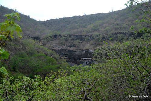
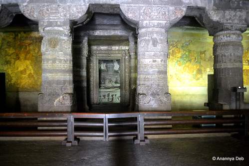
First of all, the size of the prayer hall (chaityagriha) at Kanheri and Karla are among the largest of all the cave monasteries that have been found. With a wide courtyard in front, this particular facility is well suited for large gatherings to assemble and mingle freely with ample space for everyone.


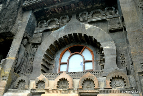
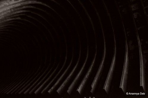
 The chaityagriha of Kanheri

Kanheri Caves, Mumbai, December 2011

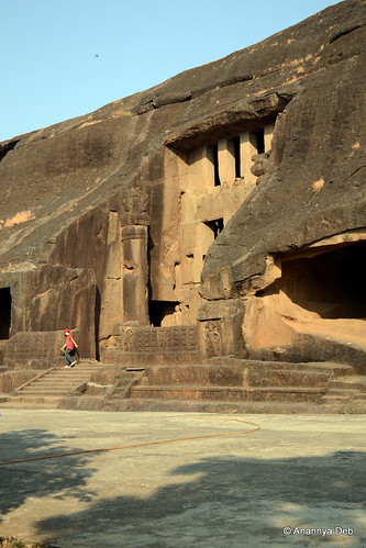
The great hall at Karla
Karla Caves, June 2014


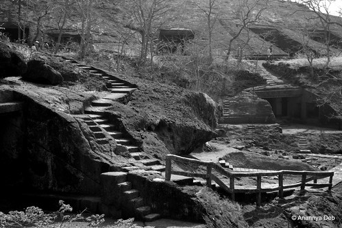
For the seclusion of the inmates i.e. the residences of the monks, once you turn round the curve and go deep into the hill, you see a whole warren of caves. They are distinctly invisible from the road below and even from the main prayer hall, they require a little effort in climbing up. Thus both the needs are met. Similar concepts can be found in design of many modern day educational complexes where the main classrooms and office buildings are easily accessible from the road while the rooms for the faculty and the students hostels are hidden somewhere at the back.


 The viharas (residences) of the monks at Kanheri

Kanheri Caves, February 2014


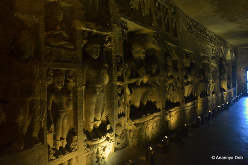
And what about the ornate artworks? Almost every cave has a recorded history (through inscriptions) of excavations and modifications ranging from 500 years to over 1000 years. During this period, Buddhism also saw a transformation from the more austere Hinayana to the more extravagant Mahayana where the likeness of the Buddha could now be carved out in various forms. Just like the Renaissance period in art came from the need to illustrate and bring to life stories from the holy book, the Mahayana period saw craftsmen bring out the different stories, themes and ideas of the Buddha and Buddhism in stone form (and mural work in the case of Ajanta).


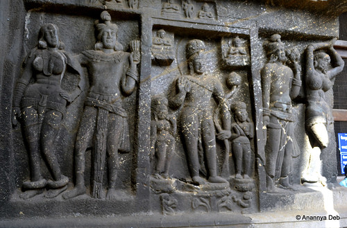
Sculptures at Panduleni (Nashik)
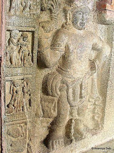
Buddhist Art, Pandavlena Caves, Nashik, August 2010

 Sculptures at Karla

Karla Caves, June 2014

Cave 1 in Ajanta – the iconic paintings flanking the Buddha

Cave 1, Ajanta, July 2014


As a history buff, making this “trail” albeit  serendipitously  provides a nice sense of achievement for me. Instead of randomly visiting discrete places, there is a nice thread emerging out of these visits. There are some trails which I have been following quite consciously – like  visiting  various imperial capitals in the Deccan peninsula and so on. But this particular discovery for myself feels good.

Why so secret? The Ajanta Experience

The first thing that strikes one is how thoroughly concealed these caves are. You can only see it once you are in the complex. No one, even a kilometre away, would have a clue that something like this exists. On three sides, it is hemmed in by hills. And from the north side, you only see the back of the hill. One can’t even see it from the MTDC facilities at the entrance. You climb up the stairs, turn round the curve of the hill and there in front of you, they stare back at you. It is not difficult to reach. But you will never know where is it.

Ajanta Caves, July 2014The first sighting of the caves, if you follow the present day access road


Every one knows the terrain and the shape and the contours and other topographic details of the caves.As the Waghor river snakes through the hills making one hairpin bend after another (or horseshoe bend), you have pairs of basalt hills side by side separated by the river. On one particular bend, the caves are cut on the southern face of a hill on the north bank. If you come from the north, you can’t see it. The hill on the south bank completely hides it from view if you are on the highway in the south. There are no access points from east or west as you have hills interlocking and creating a natural curtain of sorts.

Waghora River, Ajanta, July 2014Following the Waghor river from the north east side towards the caves


My immediate thought was that these caves were designed for absolute seclusion. Almost all the other cave monasteries that I have been to can be seen from the plains below. Travelers on the road below can sight them easily and work their way towards them for shelter and or enlightenment. Not so for Ajanta.

A similar concept can be seen in forts where the gates are hidden from view. But the difference is that the fort builders have to design and build their fort walls in a way such that the gates are hidden. In the case of the caves of Ajanta, the effect of concealment is a natural feature.

After pondering all this, my next thought was why and how did the first batch of monks choose this location. Were they being persecuted and needed to hide? Were they working on something that was very sensitive and needed to be done in a place where there was no prying eyes. Kanheri and similar caves provided seclusion but they were very much open to public view. Who selected this location? Did that person have a similar accidental discovery as the Englishman who found it in the early part of the 19th century? There must have been something in the Buddhist pioneer’s mind which led him to pick this very specific horseshoe bend of the river. One will never know and therefore one can only imagine many possible scenarios, one as crazy and wild as the other.

Cave 9, Ajanta Caves, July 2014Cave 9, a chaitya hall excavated circa 1st century BCE, part of the initial set of caves


Once one cave was excavated, circa 2nd century BCE, and populated by a few monks, the other caves started coming up. This went on for hundreds of years till about the 1st century CE. Walter Spink, one of the leading researchers on Ajanta, is of the view that the caves were abandoned from the 2ndt century CE till the 5th century CE. After that, for about a hundred odd years, kings, noblemen and commoners donated to the excavation and artistic development of the site which was now inhabited by a new generation of monks. Which means that the place was well known in most parts of the country in those times and Buddhist monks consciously chose that secluded spot for their monastery. Here again there are some thoughts that get triggered as you see each cave.

Monks would most probably be drawn to this complex because the incumbent people must have been some kind of masters and leaders in their field of thought. Almost every cave which served as a dormitory had at least three discussion spaces – a large pillared hall inside, a verandah and an open courtyard by the river. Spending time with these monks must have been extremely fruitful for students of Buddhism – both young initiates into the monastic order and visitors who cut across royalty and commoner. This is validated with the inscriptions found everywhere. It is also validated by various travelogues of those times including Huein Tsang.

The level of artistic brilliance on display is at a level far superior to what we see today. Let’s assume that craftsmen of those times produced extraordinary work for even the most mundane commissions. But this is not a mundane commission. This is an ultra secluded Buddhist sanctuary, one of thousands in the country, virtually invisible even to villagers in nearby areas and the craftsmen produce work which is, as per all the such caves which have been studied, one of the best there is. Surely they were briefed that these caves were special. So what was so special that was happening in this cave, first between the 2nd century BCE to 1st century CE and then again in the 5th century CE?

Cave 29, Ajanta Caves, July 2014Cave 29, one of the last caves to be done, outdoes all the others in terms of the sculptures


And why did it disappear from all consciousness? Coming back to Kanheri, there are inscriptions of 11th century CE of Parsees visiting the caves and meeting the Buddhist inmates there. Which means for at least 600 years after the last known inscription in Ajanta, Kanheri continued to function. But Ajanta seemed to have gone into a decline earlier than the others.

Walter Spink puts it to the decline of Buddhism and the rise of Hinduism as the state religion of most monarchs in the Deccan Peninsula. This loss of royal patronage could be one of the reasons. Possibly, the secret location turned out to its own nemesis as the monasteries remained out of sight and out of mind for most people, especially the various new empires, like the Rashtrakuta (which sponsored the Ellora Caves and some of the Elephanta cave temples), Chalukyas, etc. many of whom might still have supported them as they were known to be secular.

So who were these Buddhist masters who needed such an extreme level of seclusion? Did they achieve their goals which they had set for themselves? And who were the craftsmen who created all these works which would lie hidden in the jungles for over 1400 years?

More photographs of my Ajanta trip can be found here.

Sri Lanka Diaries – Dagoba Hopping in Anuradhapura

Anuradhapura, as the history books tell us, was the first capital of the Sinhala kingdom and the main Buddhist centre on the island. Today, there are two towns, like any historic city. There is the sacred city which is a UNESCO World Heritage site and there is the new town where local industry and the population live.

Typically, all the hotels, guest houses, home stays, etc are in the new town. The buses and trains also bring you here. On the first day I was here, I decided to venture out walking to the sacred city area.  The three wheeler autorickshaws were offering a full tour of the area for 3500 LKR (all tickets included). The general information I had was that one needed to buy tickets to access the area. The ticket value was LKR 3500 (but for Indians and other SAARC countries, there was a 50% discount). Later I found out, after buying a ticked for LKR 1750, that the tickets were only for the museums. In general all the other places were freely accessible. Most of them were holy sites which were still in use. So there were restrictions like leaving your slippers, dress code and body searches. But no monetary restrictions.

I thought the distance of 4 kms was easily manageable. I miscalculated the heat of the sun. But I did not want to take an autorickshaw and commit to a full tour. I wanted the flexibility to walk up, see the area and if I liked it then enter and engage with it. So I kept it simple. I found an auto driver who wasn’t very pushy. He dropped me at the entrance of the Maha Bodhi Tree.

Entrance path to the Maha Bodhi Tree From Sri Lanka Holiday

The Bodhi tree was planted when a cutting from the original tree in Gaya was brought here by Sanghamitta, daughter of Asoka in the 3rd century BCE. Her brother Mahinda had come earlier and had already converted Tissa, the third of the Sinhala kings. This was the birth of Buddhism in the country.

The tree stands till today but is heavily fenced.

From Sri Lanka Holiday

But the area around the tree is a throbbing place. This was the week leading to the Sinhala New Year and there were people thronging the area dressed in all whites.

From Sri Lanka Holiday

The place was decorated by multi-coloured patakas, the ubiquitous Buddhist pennants that are hung all over the place. It gave the whole area the feel of a fair without making it trivial or frivolous.

After spending about half an hour here, I started walking around the area.

From Sri Lanka Holiday

The entire place is littered with artefacts, structures (some in excellent condition, some merely blocks of stone). The first thing that strikes you is the sense of calmness – in all aspects. There is cleanliness on the roads and most importantly on the sides of the roads. There was order amongst the Lankans as they lined up peacefully to enter or exit the respective areas. There was no loud music playing on country made loud speakers. Traffic was sparse but orderly.

From Sri Lanka Holiday

Even taking photographs of water lilies could be done without worrying about any plastic shit floating on the waters.

A smallish dagoba on the side of the road    From Sri Lanka Holiday

The stupas of India and the pagodas of Burma are called dagobas in Sri Lanka. They are numerous. Spotless white, I had to really adjust my camera settings to distinguish the domes from the white clouds in the background.
As I said earlier, I did pay LKR 1750 at the Archaeological Museum. The ticket mentioned that I could enter three museums. I went into the first. There were two things that I found really interesting. The building itself and this giant lizard that kept running around.

A giant lizard scampering around the museum grounds   From Sri Lanka Holiday
The Verandah of the museum       From Sri Lanka Holiday

The entire sacred city area is spread over some stunning greenery.

The green areas around the different structures    From Sri Lanka Holiday

Everywhere there were odd stones, dolmens, monoliths, etc sprayed around. Some were randomly scattered, others were arranged in some geometric structure suggesting that there was some human activity here.
The Ruwanwelisaya Dagoba is the biggest of them all in Anuradhapura. It is also in active service. There was a fair crowd making its way in and out of the complex. Once again the cleanliness of the area was the first thing that caught the eye. Anyone who has seen any temple site in India will immediately wonder at the difference in attitude in an island which is just across a few kilometres away (the distance between the Indian coast and the Mannar jetty)

The Ruwanawelisaya     From Sri Lanka Holiday

I completed the walk about with a visit to Abhaygiri. This site is a ruin in the truest sense. But well kept of course. A bit far away from the Ruwanwelisaya, one had to take an autorickshaw to it. But it was worth the visit.

The Abhayagiri From Sri Lanka Holiday

The Abhayagiri vihara was a full fledged Buddhist monastery. The entire area shows evidence of living quarters, dining halls, pools for taking bath and latrines. One key element of Sri Lankan Buddhist architecture is the moonstone (not to be confused with the gemstone) – a crescent shaped stone platform on which are built the steps leading to any structure. From plain simple stone platforms to intricately carved ones (from what is possible to see today after all the erosion caused by weather and billions of human and canine feet). Later when I was seeing other places in Sri Lanka, this moonstone element seemed ubiquitous – from doormats to the leading step of a house to small souvenirs.

From Sri Lanka Holiday

I spent maybe 4 hours tramping around with an occasional ride in an autorickshaw when the heat became unbearable. Drinking lots of water along with puffing of the odd cigarette, I had a quiet but extremely filling day. I closed it with the physical filling of fried rice and chicken curry.

From Sri Lanka Holiday

That’s it for now.

Sri Lanka Diaries: Anuradhapura 8th April till 13th April 2012

In my last post I mentioned how I came to be at Lake Wave Rest in Anuradhapura. I strongly recommend fellow backpackers to check out this place when they are in the area.

My original idea was to stay in Anuradhapura for two days before heading to Polonnaruwa and Sigiriya. But as it turned out, the place was so comfortable and charming, I ended up staying here for five nights. I did make a couple of day trips to Mihintale and Sigiriya.

My first impression of Anuradhapura was the emptiness. I reached here on Sunday and the roads, parks, markets, etc were empty. It was also afternoon time and the heat may have had a role to play in the emptiness. In the evening when I stepped out for a walk, there was a little buzz around the New Bus Stand (and the shops in the area). One must also confess that one is prejudiced by the sheer volume of people one sees on the roads of Mumbai. Coming to a town whose population is less than 5% of Mumbai, the contrast just hits you.

From Sri Lanka Holiday

There are three things of interest for the traveler like me – history, people, peace. And to top it all, the layout of the place makes for easy exploration either by walking or by cycling. There is the heat of course but then living in the tropics is all about that anyway. Of course, those with the money to spend did hire air conditioned cars or vans to take them dagoba hopping.

My stay in Anuradhapura went like this

  • 8th April: Reached around 2 pm, checked into Lake Wave Rest, went for a walk, had a beer and kottu near the bus stand, came back by 7pm chased by a thunderstorm
  • 9th April: Went exploring around the ancient city – the Maha Bodhi Tree, the Museums, the Dagobas, the ruins of ancient monasteries, etc. , ate chicken curry and rice; returned in the evening again chased by a thunderstorm
  • 10th April: Took a day trip to Mihintale, splurged a bit on lunch and was back at the hotel by sundown. For the third day running, we had a thunderstorm with lightning tearing down trees.
  • 11th April: I had originally planned to check out and go to Polonnaruwa. But Upali, the owner of Lake Wave, very easily convinced me to stay back. It was the Sri Lankan New Year in a couple of days and he said we can have a nice party. In hindsight, I made the right decision because the friends I made in the two days I stayed back. So instead of packing up, I decided to do a day trip to Sigiriya. This was also the day when they gave the tsunami alert. While Sigiriya is quite far from the shore, there was definite concern on the faces of everyone on the streets and in the restaurant where I was having lunch. The trauma of 2004-5 was not forgotten. I returned late in the evening once again caught in a storm. There were two new guests in the hotel and the night was spent over beer, guitar strumming and discussions about world peace.
  • 12th April: With my new friends, I went exploring on the cycle, this time going to places which I missed out on the first day. As is wont to happen, I had a flat tyre and had to return hauling the errant cycle in a rickshaw. The night was again a long one with cigarettes, beer, guitar and world peace discussions.
  • 13th April: The Sri Lankan New Year, a holiday, I along with B from Germany decided to hop over to Trincomalee. Sri Lanka roads on a holiday (I may be generalising on the basis of one day’s observations) resemble a bandh in Kolkata. Not a soul in site, no traffic, no transport and even the schedule of state-run buses are a matter of conjecture.

To close this post, a summary of my five days in Anuradhapura, I leave you with three images that shall always be, for me, synonymous of the place.

Sleepy hammocks              From Sri Lanka Holiday
Buddhist Colour              From Sri Lanka Holiday
Serene Walks                From Sri Lanka Holiday

South East Asia 2011 Diary: Wat-hopping on a cycle in Ayuthaya

If Ayodhya in India is all about Ram temples (or temples to various characters in the Ramayan), its Thai namesake Ayuthaya is all about Buddhist monastery temples (or their ruins) called Wats. The word itself derives from a word in the ancient Indian language Pali.

Ayuthaya was the former capital of Siam and at its peak in 17th and 18th century was one of the leading cities of the world in terms of trade, commerce and general influence. According to the local history, the city was destroyed by the invading Burmese in 1767 and the capital then moved south.

This was my second visit to Ayuthaya and this time, having had visited Ayodhya, took a fresh look at the city. It was a hot day and the choice of taking a cycle around made me seriously regret not having learnt how to ride a motorbike (which are also available on rent).

This slideshow requires JavaScript.

What caught my notice was the number of Japanese tourists. No doubt for them this holiday would be more than just a few days of work. One could see some of the older tourists spend a lot of time in front of the various images of the Buddha.

The international crowd at the Wat Mahathat represented all nationalities all patiently and respectfully moving around the structures. Interestingly no graffiti on the walls as one is accustomed to India. No couples sitting quietly under a tree (maybe there are other quiet places on the river banks maybe).

Also had an excellent lunch (chicken with basil and rice) at Mint Guest House near the station. The wall of the guest house was full of graffiti of past travelers from Japan, Denmark, USA and UK.

It was an exhausting but enriching experience. The cycling was good exercise albeit a lot of huff and puff happened. The traffic was easy to manage including a major highway that cuts across the city. Bookended by train rides from Bangkok, the entire day was one long calorie burnout. Excellent. But next time, I will probably come having learnt to ride a motorbike or a scooter.

This is the first post of my South East Asia holiday. Tomorrow, I’ll write about roaming the waters of Bangkok.

Profiling Roads: Bhopal – Raisen, MP

The NH86 passes through Bhopal and moves north east towards Uttar Pradesh. A few kilometres out of Bhopal is the town of Raisen. Raisen is 23.33N while Bhopal is 23.25N

23.26N is the Tropic of Cancer. As you drive from Bhopal to Raisen, you will see this in your car windshield.

Tropic of Cancer in your car windshield

A closer look on the tarmac gives you this

Lines on the road surface indicating the Tropic of Cancer

The road itself winds through fields of soya, gram, wheat and sugarcane. It is a road a lot of history buffs are likely to take.

From Bhopal it links up with Raisen where a 900-year-old fort which has changed hands from one dynasty to another stands atop a hill.As one approaches Raisen, the fort looms over the dargah of Hazrat Peer Fatehullah Shah Baba. Not much is known about this Sufi saint (at least on the web) but the crowds at the shrine suggested the existence of a long standing legend. All drivers (cabbies, bus drivers, truckers, etc) halted, lit couple of incense sticks, stood for a couple of minutes and then continued their drive.

Onward from Raisen is Sanchi and Vidisha, both of which fall on the Buddhist traveler’s itinerary.

I crossed the ToC a couple of times during my work-cum-pleasure trip in Madhya Pradesh in September 2009. I wrote about it here. I wonder if similar lines have been put on other roads elsewhere – say in Gujarat