Banavasi – capital of the Kadambas

This extremely small town (or large village) with a population of less than 5000 people has this one large Shiva temple built in the 9th century CE. Most vacationing people will simply ignore this and instead carry on towards Jog Falls. Which is fine. But for those who like to explore history on their travels, a short detour to this village is worth it.

As George Moraes in his Ph.D thesis work called The Kadamba Kula writes

“The History of the Kadambas is the history of one of the most neglected, though in its own days one of the most influential, of the dynasties that held sway over the Dekkan (sic).”

The news of the city had reached Ptolemy as well and we can find the town “Banauasi” in his Geographic works. During the third Buddhist Council hosted by Emperor Ashoka, a Buddhist monk Rakkhita was deputed to this town. Obviously, as George Moraes says, it must have been an important centre for someone to be specially sent for spreading the word. And about 900 years later, in the 7th century CE, Huien Tsang mentions visiting this place (called Konkanapulo) and finding over 100 monasteries (or sanghramas) with over 10,000 priests. It is believed that with Banavasi as the base, Buddhism spread to the Konkan and other parts of Karnataka.

The Aihole inscription describes Banavasi as a city “whose wealth rivaled the gods” and then proceeds to explain how Pulakesin II of the Badami Chalukyas vanquished the Kadambas of Banavasi.

Banavasi is located in north-western Karnataka, about 120 kilometres south-west from Hubli. To its west lies the Shravati Wildlife Sanctuary up in the Western Ghats which also is the home of the highest waterfall in India, Jog Falls. The town lies on the banks of the Varada river. Like most cities across the world, this city was also established on the banks of a river. In this case, it is the Varada river which is a rain fed river rising in the Western Ghats and flowing down the slope eastwards. The Aihole Inscription mentions that the river encircled a fortress and there were birds in the river which were trained to alert the soldiers in the fortress in case they were attacked. Pulakesin II of the Chalukyas was still able to defeat them and the Aihole Inscription carries on about his greatness. Being rain fed and with a number of hydro-electric dams built along its course, there is not much water left in the river, especially in November.

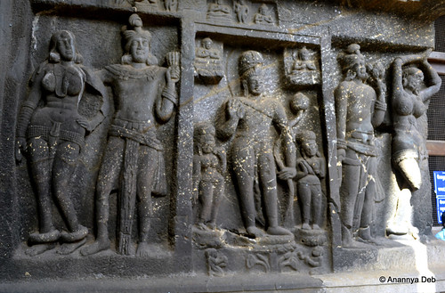
The Madhukeshwara temple is dated to the 9th century CE when the Western Chalukyas of Kalyani held sway over the land. But this temple may have been built over earlier structures as some of the inscriptions tell. Also there are various sculptures that depict different styles, namely the Kadamba, the Chalukya and later the Vijayanagara style.

Each of these styles are unique and the uniqueness is usually palpable. The main areas to focus when looking for uniqueness are a) the shikhara / vimana b) the general plan and c) the lesser number of sculptures. The Kadamba shikhara is typically a pyramid with stepped layers rising and tapering to the peak (see the picture above). You will also find Kadamba architecture in Belgaum, Belur, Halsi and Goa and other surrounding areas.

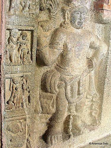
Exquisite stone work is on display like most other places in peninsular India. However, unlike the artwork in Hampi or Kanchipuram or Ellora or Pattadakal, the sculptures are extremely measured. There are sculptures of Nandi, elephants, warriors, gods and goddesses but each piece of sculpture has a lot of breathing space around it and often there are walls with nothing on it providing some relief.

I visited this town in 2013 in November. I took a state transport bus from Hubli to Sirsi, a 100km ride which took about 2 hours and a bit. From Sirsi, I took another state transport bus, but a very well decked tourist oriented bus to Banavasi, a 23 kilometre ride which took another 30 minutes. I started in from Hubli at 10:15am and I was in Bnavasi by 1.15, waiting time included. I spent 1 hour there walking around, exploring the temple and the village houses all around. By the time I finished, the next bus had arrived from Sirsi and I could take the same bus back and be on my way to Gokarna which was my main destination.

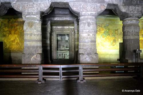
The whole village can be covered in a nice slow 30-minute walk. One passes through small institutes of art and culture including a Yakshagana theatre group. Today, there is a certain charm to this town. The old temple continues to conduct its daily rituals and hosts various festivals as per schedule. There are families coming over, one or two on a normal day, a few more on the weekend and a little more on religious holidays. But, it is a quite unassuming place. There is a resort there as well, on the banks of the river, and it advertises trips to the Jog Falls and the neighbouring forests.

Personally, the 1 hour I spent there was enough for me. It gave me what I wanted, a glimpse of what prosperity was in the first millennium and also a living proof of how a place goes into decline and fall once the political powers disappear. of course, I could tick off another important historical location in Peninsular India from my personal travel list

History Travel – The Buddhist Cave Monasteries of Maharashtra

In the previous post, I had written of the seclusion of the cave monasteries in Ajanta. In this post, I write about the exact opposite – the open, easily found monasteries between the Arabian Sea in the west and Ajanta in the east. As a traveler with a bias towards history, if I plot the various Buddhist monasteries of Maharashtra that I have visited on a map, there is an interesting observation that I make which, after reading various literature and historical studies, seems to have a clear explanation.

Starting with Kanheri in Mumbai, there is Karla (8km from Lonavala), Panduleni (Nashik), Ellora (about 10 caves) and finally Ajanta. (There are many more like Junnar, Aurangabad, Bhaja, etc. but since I have not yet visited them I will not talk about as yet. )

These five spots, when plotted on the map, reveal that they are on two lines going east from the sea – one going North East, the other South East. They run in the same direction as two major highways which emanate from Mumbai – NH3 and NH4. The ASI informs us that this is not coincidence. In effect, there were ancient trade routes from the port town of Sopara (present day Nalla Sopara) which connected with the great cities inland include Pratishthana (modern day Paithan) which was the capital of the Satavahanas who reigned between the 3rd century BCE to 2nd century CE. The immediate conclusion is that, like the serais on the Silk Route, these monasteries were specially constructed on these trade routes and served as rest places for traders.

The Western Ghats is filled with over a 1000+ such sites. And the story seems to be same for all of them. Here is an excerpt from Sukumar Duut’s Buddhist Monks and Monasteries of India.

The Deccan Trap is comparatively soft. If the monks wanted retreats on the mountain-sides, the wealthy monks would not be wanting to build them. There were winding passes and traffic for the flow of internal trade and traffic. Places, not to distant from these routes yet a suitable remove to be secluded were naturally favoured. 

Buddhism had its golden period once Ashoka embraced and spread the Dhamma through his numerous rock edicts. As it became the religion of the people, Buddhist cave monasteries became not just residences for the practicing monks but also places which offered a number of services to the public who were of diverse background – traders, noblemen, commoners. The inscriptions in the various monasteries suggest that apart from kings, wealthy traders and noblemen donated to their excavation and construction of the various viharas and chaityagrihas.  In doing so, they thus sponsored the best craftsmen to conjure up all the classic sculptures and art that you can see in these monasteries.

So with this in mind, one can now look at the different embellishments done at these caves and try to imagine how they may have served both the monk looking for seclusion and the weary traveler looking for rest and recreation (and some mental happiness).

First of all, the size of the prayer hall (chaityagriha) at Kanheri and Karla are among the largest of all the cave monasteries that have been found. With a wide courtyard in front, this particular facility is well suited for large gatherings to assemble and mingle freely with ample space for everyone.


 The chaityagriha of Kanheri

Kanheri Caves, Mumbai, December 2011

The great hall at Karla
Karla Caves, June 2014


For the seclusion of the inmates i.e. the residences of the monks, once you turn round the curve and go deep into the hill, you see a whole warren of caves. They are distinctly invisible from the road below and even from the main prayer hall, they require a little effort in climbing up. Thus both the needs are met. Similar concepts can be found in design of many modern day educational complexes where the main classrooms and office buildings are easily accessible from the road while the rooms for the faculty and the students hostels are hidden somewhere at the back.


 The viharas (residences) of the monks at Kanheri

Kanheri Caves, February 2014


And what about the ornate artworks? Almost every cave has a recorded history (through inscriptions) of excavations and modifications ranging from 500 years to over 1000 years. During this period, Buddhism also saw a transformation from the more austere Hinayana to the more extravagant Mahayana where the likeness of the Buddha could now be carved out in various forms. Just like the Renaissance period in art came from the need to illustrate and bring to life stories from the holy book, the Mahayana period saw craftsmen bring out the different stories, themes and ideas of the Buddha and Buddhism in stone form (and mural work in the case of Ajanta).


Sculptures at Panduleni (Nashik)
Buddhist Art, Pandavlena Caves, Nashik, August 2010

 Sculptures at Karla

Karla Caves, June 2014

Cave 1 in Ajanta – the iconic paintings flanking the Buddha

Cave 1, Ajanta, July 2014


As a history buff, making this “trail” albeit  serendipitously  provides a nice sense of achievement for me. Instead of randomly visiting discrete places, there is a nice thread emerging out of these visits. There are some trails which I have been following quite consciously – like  visiting  various imperial capitals in the Deccan peninsula and so on. But this particular discovery for myself feels good.

The City of Victory – 1 – The town

I learnt that Bijapur is a colloquial form of Vijaypur, the City of Victory. It dates back to the 10th century and is believed to have been founded by the Chalukyans of Kalyan. However, anybody who opens his school history textbook (at least those in Maharashtra and Karnataka) are likely to hear of Bijapur from the days of the Adilshah.

In SSC (Maharashtra Board) text books, the Adilshah of Bijapur is the villain. Chhatrapati Shivaji Maharaj is the hero. The latter becomes the ruler of Maharashtra after conquering all the forts belonging to the former and then killing his main man, Afzal Khan. Then, if you go to Goa, you find old houses built during the time of Adilshah of Bijapur. You find of his palaces which is now a government institution. Goa was a part of the sultanate and the Portuguese had to battle it out from them. Also, the standard trivia quiz question about Bijapur was pertaining to the Gol Gumbaz, the biggest domed structure in India.

DSC_3778
The Gol Gumbaz in Bijapur

All these years, as I keep adding to the list of places to travel to, Bijapur was not there. I didn’t really see much point in going there. There was Hampi on the list. But not Bijapur. It got added to the list when I started reading about the history of the Deccan sultanates and the Vijayanagar empire. Any city that grew and became such a major influence in the national narrative needs to be visited.

There are three different cities in Bijapur.

There is the modern town with its air conditioned shops, large noisy SUVs, bustling traffic, people busy on their way to their factories, businesses and offices.

There is the old town with its broken forts, havelis, mosques, markets and tombs.

But in between the two there is a third town trying to find itself.

The horse buggy (tanga) that I hired for the day was just that. A vehicle that continues to stay in the past but providing a modern day touristy service. The tangawala has a mobile phone which he will give you to call him whenever you are ready to move to the next place. He will stop at a traffic light. In the narrow streets where vehicles can’t overtake, buses line up quietly, shirking the horns, behind the tanga as it trundles along. As the road widens and the tanga shifts to the left, the buses pass by. There is no fuss about it. The same bus honks hard when couple of pedestrians take their time crossing the road.

Bijapur, March 2013
Going around Bijapur in a tanga

The in-between city is present in the streets of the town. You can see the houses which are still inhabited. Large houses that would give the upper class Mumbaikar living in his 1 crore+ 1000 sq ft built up area posh flat an inferiority complex. Some are 18th century old structures, others more recent  i.e. early 20th century.

Bijapur, March 2013
A typical house in Bijapur. The nameplate indicates it is the home and clinic of a doctor.
Sodium light illuminates a government office set inside an old haveli
Bijapur, March 2013
The skyline of Bijapur is still dominated by a 17th century structure – the Gol Gumbaaz

The people in the town seem to know the value of their legacy. They know about the potential to make a living out of it. However, there is a diffidence to it. When compared to the brazen entrepreneurship of people in Hampi, the diffidence is surprising. There is a rich heritage in the town and there is much to share with the world at large.