Banavasi – capital of the Kadambas

This extremely small town (or large village) with a population of less than 5000 people has this one large Shiva temple built in the 9th century CE. Most vacationing people will simply ignore this and instead carry on towards Jog Falls. Which is fine. But for those who like to explore history on their travels, a short detour to this village is worth it.

As George Moraes in his Ph.D thesis work called The Kadamba Kula writes

“The History of the Kadambas is the history of one of the most neglected, though in its own days one of the most influential, of the dynasties that held sway over the Dekkan (sic).”

The news of the city had reached Ptolemy as well and we can find the town “Banauasi” in his Geographic works. During the third Buddhist Council hosted by Emperor Ashoka, a Buddhist monk Rakkhita was deputed to this town. Obviously, as George Moraes says, it must have been an important centre for someone to be specially sent for spreading the word. And about 900 years later, in the 7th century CE, Huien Tsang mentions visiting this place (called Konkanapulo) and finding over 100 monasteries (or sanghramas) with over 10,000 priests. It is believed that with Banavasi as the base, Buddhism spread to the Konkan and other parts of Karnataka.

The Aihole inscription describes Banavasi as a city “whose wealth rivaled the gods” and then proceeds to explain how Pulakesin II of the Badami Chalukyas vanquished the Kadambas of Banavasi.

Banavasi is located in north-western Karnataka, about 120 kilometres south-west from Hubli. To its west lies the Shravati Wildlife Sanctuary up in the Western Ghats which also is the home of the highest waterfall in India, Jog Falls. The town lies on the banks of the Varada river. Like most cities across the world, this city was also established on the banks of a river. In this case, it is the Varada river which is a rain fed river rising in the Western Ghats and flowing down the slope eastwards. The Aihole Inscription mentions that the river encircled a fortress and there were birds in the river which were trained to alert the soldiers in the fortress in case they were attacked. Pulakesin II of the Chalukyas was still able to defeat them and the Aihole Inscription carries on about his greatness. Being rain fed and with a number of hydro-electric dams built along its course, there is not much water left in the river, especially in November.

The Madhukeshwara temple is dated to the 9th century CE when the Western Chalukyas of Kalyani held sway over the land. But this temple may have been built over earlier structures as some of the inscriptions tell. Also there are various sculptures that depict different styles, namely the Kadamba, the Chalukya and later the Vijayanagara style.

Each of these styles are unique and the uniqueness is usually palpable. The main areas to focus when looking for uniqueness are a) the shikhara / vimana b) the general plan and c) the lesser number of sculptures. The Kadamba shikhara is typically a pyramid with stepped layers rising and tapering to the peak (see the picture above). You will also find Kadamba architecture in Belgaum, Belur, Halsi and Goa and other surrounding areas.

Exquisite stone work is on display like most other places in peninsular India. However, unlike the artwork in Hampi or Kanchipuram or Ellora or Pattadakal, the sculptures are extremely measured. There are sculptures of Nandi, elephants, warriors, gods and goddesses but each piece of sculpture has a lot of breathing space around it and often there are walls with nothing on it providing some relief.

I visited this town in 2013 in November. I took a state transport bus from Hubli to Sirsi, a 100km ride which took about 2 hours and a bit. From Sirsi, I took another state transport bus, but a very well decked tourist oriented bus to Banavasi, a 23 kilometre ride which took another 30 minutes. I started in from Hubli at 10:15am and I was in Bnavasi by 1.15, waiting time included. I spent 1 hour there walking around, exploring the temple and the village houses all around. By the time I finished, the next bus had arrived from Sirsi and I could take the same bus back and be on my way to Gokarna which was my main destination.

The whole village can be covered in a nice slow 30-minute walk. One passes through small institutes of art and culture including a Yakshagana theatre group. Today, there is a certain charm to this town. The old temple continues to conduct its daily rituals and hosts various festivals as per schedule. There are families coming over, one or two on a normal day, a few more on the weekend and a little more on religious holidays. But, it is a quite unassuming place. There is a resort there as well, on the banks of the river, and it advertises trips to the Jog Falls and the neighbouring forests.

Personally, the 1 hour I spent there was enough for me. It gave me what I wanted, a glimpse of what prosperity was in the first millennium and also a living proof of how a place goes into decline and fall once the political powers disappear. of course, I could tick off another important historical location in Peninsular India from my personal travel list
Why so secret? The Ajanta Experience

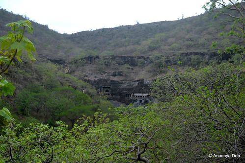
The first thing that strikes one is how thoroughly concealed these caves are. You can only see it once you are in the complex. No one, even a kilometre away, would have a clue that something like this exists. On three sides, it is hemmed in by hills. And from the north side, you only see the back of the hill. One can’t even see it from the MTDC facilities at the entrance. You climb up the stairs, turn round the curve of the hill and there in front of you, they stare back at you. It is not difficult to reach. But you will never know where is it.

Ajanta Caves, July 2014The first sighting of the caves, if you follow the present day access road


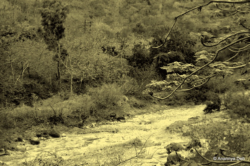
Every one knows the terrain and the shape and the contours and other topographic details of the caves.As the Waghor river snakes through the hills making one hairpin bend after another (or horseshoe bend), you have pairs of basalt hills side by side separated by the river. On one particular bend, the caves are cut on the southern face of a hill on the north bank. If you come from the north, you can’t see it. The hill on the south bank completely hides it from view if you are on the highway in the south. There are no access points from east or west as you have hills interlocking and creating a natural curtain of sorts.

Waghora River, Ajanta, July 2014Following the Waghor river from the north east side towards the caves


My immediate thought was that these caves were designed for absolute seclusion. Almost all the other cave monasteries that I have been to can be seen from the plains below. Travelers on the road below can sight them easily and work their way towards them for shelter and or enlightenment. Not so for Ajanta.

A similar concept can be seen in forts where the gates are hidden from view. But the difference is that the fort builders have to design and build their fort walls in a way such that the gates are hidden. In the case of the caves of Ajanta, the effect of concealment is a natural feature.

After pondering all this, my next thought was why and how did the first batch of monks choose this location. Were they being persecuted and needed to hide? Were they working on something that was very sensitive and needed to be done in a place where there was no prying eyes. Kanheri and similar caves provided seclusion but they were very much open to public view. Who selected this location? Did that person have a similar accidental discovery as the Englishman who found it in the early part of the 19th century? There must have been something in the Buddhist pioneer’s mind which led him to pick this very specific horseshoe bend of the river. One will never know and therefore one can only imagine many possible scenarios, one as crazy and wild as the other.

Cave 9, Ajanta Caves, July 2014Cave 9, a chaitya hall excavated circa 1st century BCE, part of the initial set of caves


Once one cave was excavated, circa 2nd century BCE, and populated by a few monks, the other caves started coming up. This went on for hundreds of years till about the 1st century CE. Walter Spink, one of the leading researchers on Ajanta, is of the view that the caves were abandoned from the 2ndt century CE till the 5th century CE. After that, for about a hundred odd years, kings, noblemen and commoners donated to the excavation and artistic development of the site which was now inhabited by a new generation of monks. Which means that the place was well known in most parts of the country in those times and Buddhist monks consciously chose that secluded spot for their monastery. Here again there are some thoughts that get triggered as you see each cave.

Monks would most probably be drawn to this complex because the incumbent people must have been some kind of masters and leaders in their field of thought. Almost every cave which served as a dormitory had at least three discussion spaces – a large pillared hall inside, a verandah and an open courtyard by the river. Spending time with these monks must have been extremely fruitful for students of Buddhism – both young initiates into the monastic order and visitors who cut across royalty and commoner. This is validated with the inscriptions found everywhere. It is also validated by various travelogues of those times including Huein Tsang.

The level of artistic brilliance on display is at a level far superior to what we see today. Let’s assume that craftsmen of those times produced extraordinary work for even the most mundane commissions. But this is not a mundane commission. This is an ultra secluded Buddhist sanctuary, one of thousands in the country, virtually invisible even to villagers in nearby areas and the craftsmen produce work which is, as per all the such caves which have been studied, one of the best there is. Surely they were briefed that these caves were special. So what was so special that was happening in this cave, first between the 2nd century BCE to 1st century CE and then again in the 5th century CE?

Cave 29, Ajanta Caves, July 2014Cave 29, one of the last caves to be done, outdoes all the others in terms of the sculptures


And why did it disappear from all consciousness? Coming back to Kanheri, there are inscriptions of 11th century CE of Parsees visiting the caves and meeting the Buddhist inmates there. Which means for at least 600 years after the last known inscription in Ajanta, Kanheri continued to function. But Ajanta seemed to have gone into a decline earlier than the others.

Walter Spink puts it to the decline of Buddhism and the rise of Hinduism as the state religion of most monarchs in the Deccan Peninsula. This loss of royal patronage could be one of the reasons. Possibly, the secret location turned out to its own nemesis as the monasteries remained out of sight and out of mind for most people, especially the various new empires, like the Rashtrakuta (which sponsored the Ellora Caves and some of the Elephanta cave temples), Chalukyas, etc. many of whom might still have supported them as they were known to be secular.

So who were these Buddhist masters who needed such an extreme level of seclusion? Did they achieve their goals which they had set for themselves? And who were the craftsmen who created all these works which would lie hidden in the jungles for over 1400 years?

More photographs of my Ajanta trip can be found here.

Animals on the road

A short album made up of various animals who joined the traveller on the road

Mahabalipuram

But for the fact that this is Mahabalipuram Beach and the shore temple is behind you, this kid riding a horse could be in any city beach of India.

Mahabalipuram

Dogs are everywhere.

Badami, Karnataka

In Badami, the ancient seat of the Chalukyas. The local poverty reflects in the skinny nature of the cur. Nothing much to scavenge.

Palolem, Goa

In Palolem, Goa, they join the goras in sun bathing

… or as foot rugs.

Then there are monkeys

Kanheri Caves

… in caves

Borivili National Park

… in the dry jungles of Borivili

Udaygiri

… and the Jain ruins of Udaygiri

Lonavla

Then a smattering of goats along the way

Machilipatnam

… grazing whatever grass is there in Machilipatnam beach

And finally…

Ayodhya

… the holy cow of India.

Traveling in India Experiences: Ujjain

Ujjain, October 2009 – 4 hour drive from Bhopal.

Ujjain: The Kshipra river. One of the four Kumbh Mela teerthas

I have a fascination for rivers. This is Kshipra, flows from the Vindhyas into the Chambal in central India. The town of Ujjain is also host to one of the four Kumbha Mela.  And like holy rivers, extremely polluted. One can make a simple law: pollution of a river is directly proportional to the holiness of the river.

I had earlier blogged about having bhang in Ujjain.

Across the nation – 2

I discovered the meaning of “jet-setting” albeit with an Indian touch. Or is it called “living out of a backpack”? (Well, I don’t really use a suitcase). Consider this:

Sunday, Day 1: Leave Mumbai around 5pm by cab to Nashik (around 150 kms drive). Reach Nashik by 9pm..

Monday, Day 2: Full day workshop with client in Nashik; finish by 3 pm; set off for Mumbai; reach Mumbai and home by 7 pm.

Tuesday, Day 3: 10.30 a.m. flight to Bhubaneshwar; land at 1.30 pm; head to client’s office for conference till 7 pm.

Wednesday, Day 4: Morning is free, went to Dhauli and Udaygiri; Flight to Bangalore at 1.40 pm; land at Bangalore at 3:20 pm; wait for chartered car to pick up (arrives at 7 pm); reach Hosur at 10 pm (2 hours driving through Bangalore); The original plan was to go to Salem but with rain and the late hour, decided to halt at Hosur.

Thursday, Day 5: From Hosur drive to a TN Agri University research station near Palacode / Kaveripatnam for a field visit; 2.30 pm reach Salem for lunch; 4 pm reach Attur, a large town 50 kms from Salem for another field visit; return to Salem by 7 pm.

Friday, Day 6: Spend day in Salem interacting with client project teams, reviewing their work; Free by lunch time; relax by going up to Yercaud; take 21:00 hours Salem-Chennai Express to Chennai.

Saturday, Day 7:  Reach Chennai Egmore at 4.50 a.m.; sleep at client guest house till 8 a.m.; whole day client workshop; 7 pm flight back to Mumbai; 10.30 pm enter home.

7 days, 3 metros, 4 large towns, 1 historic site, 2 rural field visits, 7 different beds (one of them in the train), three different modes of transport. I know there are people who may pwn me on this front but for me this week was as close to “jet setting” as I can get.  (And did a 3 day version again last week).

New places seen since the last post Across The Nation

Chilka

The largest brackish water lake in Asia, this ecological wonder off the coast of Orissa is one of the most beautiful locations I have come across. While I came here on work, to study the fishing communities on the banks of the lake, one cannot not spend a few minutes of leisure staring out. Visiting in the third week of September, the wintering of the Siberian Crane had still not started. The locals did say that the number of birds in the area were coming down over the years.

Dhauli, Following Ashoka

Have already blogged about it, the key experience being of how the local population, even the supposedly knowledgeable tourist taxi driver, simply have no idea about the rock edicts in Dhauli and instead divert tourists to the ugly white pagoda.

Following Ashoka: The Daya river where the Kalinga war was fought

Hosur

An industrial town on the border of TN and Bangalore, over the last ten years, this place has simply boomed. But the civic infrastructure is poor and has simply not kept pace with the boom. The result is that instead of giving the appearance of a prosperous town, it looks like an overcrowded chaotic market.

A few experiences from the above places, especially Chilka, will be shared in subsequent blog posts.

Following Ashoka

It almost didn’t happen!

A work trip to Bhubaneshwar and a convenient afternoon flight meant I had the morning to spare. So decided to take use of the car available and follow Ashoka: i.e. go see Dhauli, site of Ashoka’s Kalinga rock edicts and also the purported battlefield on the banks of the Daya river. All well so far. But the driver of the car, probably because of years of training, ended up in this Peace Pagoda thingie below. I was a bit confused because a) while Buddha, Buddhism, etc were on view at this place, this building was not built in the 3rd Century BCE but in the 1960’s CE and b) where were the rock edicts.

As I sat in the car and started moving back, on the side of road saw this characteristic ASI’s blue “Protected Monument” signboard and something “Edict”. I halted the car, got out and there it was.

The driver, a local resident of Bhubaneshwar, son of the soil of Odisha, formerly Orissa, formerly Kalinga had no idea about this. And one could see thousands of people whom he may have brought here to the Buddhist temple (there is a rival Hindu temple also next to it). But unless the tourist knows about this, the driver would not have stopped here

This slideshow requires JavaScript.

As I read Romila Thapar’s Early India, and coincidentally I had reached the chapter on Ashoka around the same time as the above trip, the man behind the legend of Ashoka seems more and more enigmatic. An ambitious lad, there is, as Thapar writes, a controversy whether he fought his brothers for the throne or was it a peaceful succession. He did extend the boundaries of the Mauryan empire established by his predecessor Chandragupta and later his father Bindusara. He was quite cruel in battle and it was his cruelty in the Kalinga war that stared at him. On his remorse, which he put as part of the edicts, though not in Dhauli, he says:

“On conquering Kalinga the Beloved of the Gods (Devanampiya Priyadasi – what Ashoka called himself) felt remorse, for when an independent country is conquered the slaughter, death and deportation of the people is extremely grievous to the Beloved of the Gods and weighs heavily on his mind.”

“The participation of all men in suffering weighs heavily on the mind of the Beloved of the Gods.”

(this is from Romila Thapar’s translation of the Major Rock Edict XIII)

The use of the third person “Devanampiya Priyadasi” i.e. Beloved of the Gods Priyadasi (later used by Indira Gandhi) suggests a man filled with ego. Even after taking up Buddhism, moving towards non-violence, he continued to expand his empire and used the length and breadth of his reach to spread Buddhism. He himself, it is said, travelled to all parts of his realm and pillar edicts in Gandhara (Afghanistan), Swat Valley, Karnataka, Junagadh, etc are testimony to that. A megalomaniac maybe.

Whatever he may be, from India’s early history point of view, it was a turning point. The Mauryan Empire was the first real imperial system in the subcontinent and it marked the evolution from clan-based chieftains, minor kingdoms, city-states to large cosmopolitan social systems with the state (the emperor) play a lead role in defining morality, the rules of behaviour, ethics, etc.

If only the driver knew and took everyone there instead of the boring temple.

Ancient Monuments, Archaeological Sites and Remains in India

The 1958 Ancient Monuments, Archaeological Sites and Remains Act mandates the almost 150 year old Archaeological Survey of India to research, maintain and protect the cultural heritage of India.  Since partition in 1947, the ASI today has about 3600 sites under its custodianship. While it may be doing a fair job of researching, maintaining and protecting, it is certainly lacks the capability to leverage these sites in terms of tourism and cultural development.

The onus of that falls on local bodies who may see the potential in these sites. Even here, there is some kind of a stratification. There are the World Heritage sites led by the Taj Mahal. These sites are like the pampered sons in a family. Beautiful manicured lawns, spotless clean walkways, regular cleaning, security, etc etc etc. Humayun’s Tomb is another example. In all these places, the contribution is made by specific agencies like the tourism department or specific trusts which look after these sites. In the case of Humayun’s Tomb in Delhi, it is the Aga Khan Trust.

Humayun's Tomb: Spick and Span

Contrast this with other historically significant sites but not necessarily high profile and glamourous. At least it does not fall in the regular tourist trail. For example Aihole. Take any of the top travel sites and you will not come across this place in the list of destinations. In fact, you may be able to search for it in Google Maps. Fortunately there is a wiki article.

The state of repair (or disrepair) of the first capital of the early Chalukyas and the nursery of classical Indian architecture is in sharp contrast to Humayun’s Tomb. While there is one part which is fenced with green lawns, there are hundreds of other sites scattered all over the place. And most of them you would actually miss because they are almost like dump zones for the local villages.

Aihole: 1000 year old structures meant for kings now serve as dump zones

The fundamental problem with ASI is that they seem to have strictly drawn the line with “protect the monument” mandate. But monuments and sites like these cannot be protected where the present day communities consider them as unproductive occupiers of space. Whether in backward villages or city slums, these monuments will become filthy and destroyed. And will completely vanish from the maps. Many Buddhist and Hindu caves in Mumbai city itself are completely engulfed with slums.

The solution is not to remove these villagers or slum dwellers but to include them into the picture. The ASI (or if they can’t do it, any other competent body) should look at developing a sense of purpose with these local communities. Treating these sites as assets with potential to earn revenues through tourism, locations for film shooting, research and education, etc these communities can be co-opted into preserving them. It will build a sense of pride. After all, in many cases like Murud Janjira, most of the locals are in a way descendents of people who once flourished in these parts of the world.

Tourism is a big industry and is something that the local communities can and will adopt as a big livelihood earner. This is where the ASI’s narrow “protect the monument” muzzle fails.

Lost and Found in The Labyrinth

Daedalus built the Labyrinth as a prison to hold the Minotaur. It was a structure designed to confuse. Designed for people to get disoriented and hence imprisoned by their own sense of bewilderment. One thing that a Labyrinth should not have is a window or multiple doorways. This automatically gives the intelligent person the opportunity to get a sense of where he or she is. However, it is for each one to test the GPS system inbuilt in one’s brain.

Last week I was in Lucknow and after we finished our work, had a couple of hours before the flight. The decision was to go to Bara Imambara. The complex is, well, complex.

The Bara Imambara – Second Gate

The Lucknow Bhul Bhulaiya or labyrinth is not so “difficult” to navigate. Built atop the central hall of the Bara Imambara, there are series of balconies and grilled windows (jharokas) that give you a glimpse of where you are and which way you should go.  Apparently the whole thing came about because of the design of the central halls.

The main hall of the Imambara, 50×16 is 15 metres tall without any central pillars or columns supporting it nor any girders. It is an arched ceiling made with interlocked bricks and stone. Along with the central hall where Asaf-ud-Daulah and the architect Khifayatullah are both buried, there are a number of other smaller halls of different dimensions including height.

The Central Hall is 50×16 with a height of 15 metres. There is no central column or pillar. In the back, the tent-like canopied space is the tomb of Asaf-ud-Daulah. Up you can see some windows and balconies. They are part of the Bhul Bhulaiya

This variable heights of different parts of the base structure gave rise to the maze on the roof. Building small doorways, 487 in all, the roof became an intricate network of passages. This can be seen from down as well.

Bara Imambara: The balconies are part of the Bhul Bhulaiya, One of the side halls in the base of the structure. The height is different (a bit lower). You can see two balconies up there.

In theory, the labyrinth is a single unambiguous path that leads to a point and one must simply walk back the same way. A maze is where a path breaks off into multiple paths, each of these paths subsequently breaking off into other paths, etc. The Lucknow Bhul Bhulaiya falls in the second category.

The first set of steps, 45, that lead you to the first level of the Bhul Bhulaiya. As you can see, there is sunlight to guide you

Once you enter the maze, you have at various points choices of choosing paths – usually steps rising or descending. It is quite funny but in the day time, usually, one of the paths will always lead to a part of the maze which has direct sunlight thus reducing the mystery. To use an old cliche, there is always light at the end of a tunnel.

Navigating the maze – the light at the end of the tunnel

There is really no sense of disorientation really. The entrance is on the east side (left) of the central hall (hall is roughly oriented on the west-east plane). As you enter, you have a sense that north (where the gates are) is on your right and the entrance (east) is behind you. Even after a few turns, you can still retain that. At least I could. What helped me significantly were of course these balconies that looked onto the central hall. The lighting system (or lack thereof) made the whole place look quite psychedelic if I may say so.

Looking into the hall from one of the balconies of the maze. The lighting – a heady mix of sunlight (direct, reflected and diffused) and electricity

Incidentally, economists may well have an interest in this monument. The Nawab of Awadh (Oudh for the Anglo) Asaf ud-Dowlah had moved his capital from Faizabad to Lucknow in 1775. However famine struck and people left the fields and migrated to the city looking for food and survival. The Nawab initiated the construction of this complex. The famine last a decade, the construction went on for that time. According to the wikipedia entry, the legend says that the ordinary people would build in the day time and go off for the night. The noblemen, the wastrels who had no skill nor ability, were told tear down whatever was built. This kind of predates Keynes and his theory of digging trenches, filling them up and digging again.

From the top of the Imambara, one can scan the entire complex and beyond

Over this period, besides the Imambara halls and the maze, the workers also built a Shia mosque (Asfi mosque), a step well (baoli) that leads to a bath on the Gomti, two elaborate gateways and another gate called the Rumi Darwaza. Besides these, there are supposed to be secret tunnels that lead people to Faizabad, Allahabad, Delhi, etc. Plus the regular urban legends, usually spread by the official guides, about great treasures.

This piece of architecture is also significantly different from the Mughal architecture (evidence Red Fort, Humayun’s Tomb, Taj Mahal of course, etc). The use of blue and the naming of one of the gates as Rumi Darwaza suggests Persian and Sufi influences (a legacy of lapis lazuli maybe?). Obviously, no British influence here. Given the time line, the East India Company was still settling into Calcutta and Madras.

Anyway, a good couple of hours well spent. It was a cloudy day with rain all around and the humidity made it quite a sweaty experience. But it was worth it.

More photographs in my continuous album – Traveling in India

Update: My online photo dump has been re-organised and new links are available on these two pages – The Geography Cut and The Culture Cut (Posted on 6th December 2012)

Fortress Ayodhya

On 14th, I had the opportunity of going to Ayodhya. Not that I have any great affection for things theological or devotional but I went along for the ride to see this place which can break down governments.

2.5 hour drive from Lucknow, the road keeps alternating between wide 4-lane speedway and narrow village mud paths (ostensibly a national highway with special attention given during the golden quadrilateral project). Anyway we reach in in time.

Entering Ayodhya from Faizabad

There are no photographs from the Ram Janmabhoomi. Not even a note. You can’t take anything – no pens, no phones, no camera, no purses, no bags. You have to pass through five body searches. The path, a winding one, is a covered path with metal mesh with fully armed security people standing behind sandbags pointing the gun at you. You have to keep walking at a steady pace. In fact, one was so distracted by it that one did not even notice the small tent under which the idol of Ram and his brothers had been kept. The local priest sat there distributing prasad and holy water. From the fortress like surrounding, I can conjecture, this guy must be having his dossier on all the security computers with his house watched 24/7.

One wonders whether it is all worth it. The entire complex has 6 battalions of CRPF, 3 battalions of ITBP and all of the local police force here. There is a full SP in charge of security of that one piece of turf. All of them who are on duty have to be on full alert as they watch cattle graze or monkeys pass through. The occasional VIPs who come with police passes have to be let through without losing control of the place. The sheer stress on the soldiers is simply not worth it.

This entire cost on the state to maintain some piece of land is a sheer waste. It makes one wonder whether religious institutions and the people who run it really make any contribution to society.

The rest of the town is nothing but an extended supermarket of religion. Almost every character (the good ones) from the Ramayan have their small little thrones. Cows, laddus, flowers, etc drive the local economy. Priests make up the “high networth individual” segment while government staff make up the bourgeois of the town.

Another temple in Ayodhya with its own story

The streets of the town are narrow and dirty. It would seem that the thing about getting your sins cleaned up here are reflected in the litter and general dirtiness of the streets.

Narrow streets with the paraphernalia of devotion littered around

The one pleasant site was to see the wide expanse of the Sarayu (Ghagra) river full of water. Apparently, nobody has thought of building a dam on this as yet.

The Sarayu River

The whole trip took 8 hours. We started from Lucknow at 6 in the morning. Stopping for chai and samosa on the way, some sandwiches in Faizabad, we made it to the Janmabhoomi at about 10. By 12 we were on our way back reaching Lucknow by 2.30pm.

On the way, we were held up by a railway crossing. Apparently the road bridge over it had collapsed killing people. Now, the traffic on the highway had to wait for trains to pass adding at least a 20-30 minute wait to the journey. Those standing waiting for the clearance included school buses.

Level Crossing on the National Highway

For an atheist, Ayodhya is an experience that reinforces one’s aversion to things religious.